 July 2, 2006
Hike to Tap-eo
Tap-eo
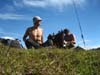
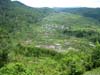
It was another promising hike planned by Aklay where we, together with Allan and Ernest are to climb
Mt. Ampacao's grassy area, then bypass the mossy forest, heading south along the ridge until we reach the village of Tap-eo. There is no road that leads to Tap-eo. It is an
isolated village of about 8 families, and located close to the top of the ridge. By road, it can be reached through the village of Balugan where the road ends. Then it's a fairly good trek through the traditional footpath
along rice terraces that climb up the slope to get to Tap-eo.
How Villages Come to be
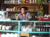
It's odd to think how 8 families would move to an isolated mountain top and establish a village. There are more villages with that number of families - it's not entirely uncommon in Sagada. This is how it begins...seriously. A pregnant pig (or dog) would stray out of the village into a remote and isolated area to bear young. That is good omen to wherever that place is. Some families might actually venture to move there for good luck. That's it. That's how remote places become inhabited villages.
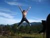
Waiting on Mt. Ampacao
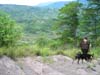
The plan was to meet Ernest and Allan on Mt. Ampacao. Along the way, I could see
Marlboro Country partially draped by fog. Upon arrival, we waited, no one showed up. Not wanting to be detered by lack of company, Aklay and I proceeded with the itinerary. Although I've seen it many times, I still can't get enough of how spectacular the
scenery is from the top.
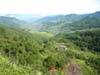
Single-Track Trails
After by-passing the mossy forest, the trail was already unfamiliar. It was single-track that was
too technical for mtb riding. Beginning at one point however, the winding trail flattened out and extended for a long stretch. It was
perfect single-track riding, with one caveat: you'd have to carry your bike a long way 'til you get there.
Water Source
We came across a
stream...time to throw away our 'city' water and get it refilled by fresh mountain spring water. Before, I thought water was water. However, when I did side-by-side water tasting between bottled Absolute distilled water and spring-fed mountain water, it was like comparing stale wine against vintage Bordeaux - no contest.
It's interesting to point out that the drinking water from a stream is no longer drinkable after it passes a village or a rice terrace. So it's important to know that the stream water you're drinking is directly coming from a spring source or the mossy forest.
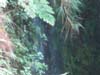
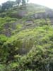
Waterfalls
The stream we were on went on through the mountain slopes, villages and rice terraces. At several points, the stream plunged down a few hundred feet as a
waterfall. There were several waterfalls we came upon. Most of the time, it wasn't possible to see the base of the fall, except to rappel down to it. Increasingly, I'm getting gung-ho about doing exactly that. We'll see.
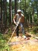
Mushroom Bacon Sandwich
We passed by a few
mushrooms but it wasn't until I saw the last one that I decided to pick it for lunch. If I came upon a mushroom patch, lunch would have been pasta with rich creamy mushroom sauce. Since
I only got one, it came down to a
bacon and mushroom sandwich on Aklay-baked whole wheat bread...yummy! By the way, I asked a local if the mushroom was edible.
Ending Thoughts
The hike took 6.5 hours. We started at 7:00am and came back 1:30pm with little rest in between. Along the trail system were more forks that led to other remote villages. The endless possibilities are there to be appreciated and explored. Sagada is inexhaustible.
I continue to be grateful to Aklay for not getting tired of tagging me along and sharing with me the trails he has discovered for himself in the last 5 years he's been in Sagada.
--- TheLoneRider

»» next story
»» back to Mountaineering
»» back to Homepage
|


 Outdoor Adventure Tours
 SandCastles Palawan Beach Resort