 October 2, 2007 October 2, 2007
HIKE TO MT. AMPACAO
Different Routes
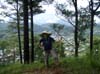
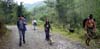
I've hiked to Mt. Ampacao a few times already. It's one of Sagada's staple hikes, given that you see the Smart cell site on top of it from the Poblacion. The beauty of the hike is that there's more than one way to reach the top - via Ambasing (the ultra-steep paved/dirt road), via Demang (the shortest but steepest hike) or via Danom (longer but more forgiving). Little did I know that there's even a variation to them - count on the frenchman for those little-known other ways. His only question before we headed out was, "How muddy do you want it?". The common reply was, "If we have to go knee-deep, we'll do it. But we'll take the cleaner way if there's one." Together with him, 2 Australians and a damsel from Romblon, we headed out via Danom.
Ridge Hiking
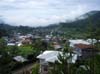
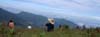
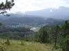
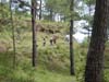
Instead of taking the dirt road that climbs from Poblacion to the Atanawan waiting shed, we took the ridge that spoiled us on another breathtaking
view of Sagada. It was a ridge I've always been curious about, but never ventured to go on my own. I'm glad it's happening now. We ultimately came upon the waiting shed, but instead of taking the beaten path, we veered again on another trail that took us to one of the
highest points on the ridge - 1732 meters from sea level.
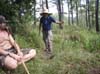
Orienteering
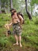
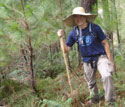
A hike is another opportunity for me to practice on my orienteering skills. Having brought my topographic map, a ruler, pencil and compass, I took line-bearings on trusted sites and plotted it on my map. Where they intersect is where I am. It's empowering to know exactly where you are on the map when all you see around you is an enormous expanse of greens, ridges and valleys.
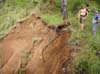
At one point, it didn't make sense. The line-bearings intersect at a valley but I wasn't on a valley. I was on a ridge. The frenchman carefully pointed out that I had my map pointing in reverse poles. ha-ha! It pays to have someone knowledgeable point out what you're missing.
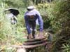
Saddle
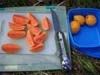
We didn't climb all the way to the tower. That would have meant another hour of steep slippery climb in thicker brush. We just stayed on the saddle (a low flat area between 2 peaks), where we rested and put out our snack pack. It was our chance to appreciate the view and small talk as well.
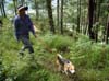
Descending
On the way down the Ambasing road, again we took the steeper foot-path instead of the dirt road. Upon reaching Ambasing, we trailed on the village path that connects Ambasing to Demang instead of the taking the road. Although the hike was a familiar one, it seemed like a new adventure having taken new trails and paths. Altogether, it was a half-day hike. It wasn't too easy but it wasn't overly grueling either...just right for a morning hike on a sunny day.
--- TheLoneRider

»» next story: Butterflied Chicken Casserole
»» back to Mountaineering
»» back to Homepage
|


 Outdoor Adventure Tours
 SandCastles Palawan Beach Resort