|
|
 |

Jun 3, 2010
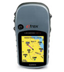
Garmin eTrex Vista HCx GPS
Rating:

 (4 out of 5 stars) (4 out of 5 stars)
Maker: Garmin
Tagline: Follow the Leader
Model: eTrex Vista HCx
MSRP: US$300
Frequency of Use: every time I travel
I was completely new to gps when I had this unit. After reading the manual to teach me how to use it, I felt overpowered. I figured that by reading the manual repeatedly, I would soon get the knack for it...NO! I concluded that a gps is a terribly hard gadget to use. It gathered dust on my shelf after that. After many months, I stumbled upon a GIS site (Geographic Information System) describing what I just went through - that many new gps users give up because they relied entirely on the manual. The site offered many tutorial links that were waaaay more understandable and friendly. That renewed my interest on this gps in particular, and GIS in general.
(company claim)
- can be loaded with a microSD card (user provided)
- bright color screen
- automatic routing
- water resistant
- functional even in deep woods or just near tall buildings and trees
- electronic compass
- barometric altimeter

- the manual sucks (like most manuals). No wonder books like "Dummies for...." sell like hot cakes.
- the one map that came with its dedicated software, MapSource was next to useless. It was an un-precise global map with corners instead of curves. While taking a waypoint near a body of water, it would show me deep in the ocean. Apo Island and some inland lakes are not there! A better approach would have been Garmin giving the user a choice of a country map, but meticulously detailed (upon online registry).
- getting a .img map, the native format for MapSource is not easy unless you buy it from them.
- even if you do buy it from them, and you're looking for a map for the Philippines, the closest thing they sell is a road map for Southeast Asia, City Navigator Southeast Asia NT, for US150. It highlights the cities Singapore, Malaysia, Thailand, Indonesia, Hong Kong and Macau. It means you'll spend US$150 for a map for cities you don't need and not enough info for the city you do need (Manila).
- if I can't find an .img map, I can use a few other formats but again, it entails using another software to convert it to an .img format.
- having sourced an .img map on the internet, or having converted one, it's still not easy to load it on the gps. I had to install 2 separate softwares to do that - MapSetToolkit and cgsmapper. At this point, I guess you get an idea how difficult it gets to use a non-Garmin map to your Garmin gps.
Ending Thoughts
As far as getting the gps to extract waypoints and tracks, which to me is the most essential feature of any gps, I have no problem with Garmin.
The beef I have with them is 1) they don't necessarily carry maps for places like the Philippines, but 2) they made it ultra-hard for anyone to use a map not purchased from them. They've already made their money on the sale of the GPS, why not cut their customers some slack?
For one thing, the emerging standard in GIS maps is the shapefile format, .shp. It's readily downloadable from GIS sites, particularly OpenStreetMap (OSM). Nearly all GIS software use that format - ArcView, MapWindow, QGIS, etc. Why can't Garmin support that file format in MapSource as well?
This would encourage buyers from countries they don't have a map for! Think about the revenue from this yet-untapped market! With stiff competition now that cellphones come with gps features (that supports OSM), Garmin should seriously rethink if they should continue this outdated 'proprietary' thinking, or accommodate an 'open source' community-based paradigm for its product mix.
--- TheLoneRider
- if you're new to GPS, use the manual to get familiar with the product features, but don't rely on the manual to learn how to use a GPS. Best to Google GPS tutorials on the internet. Trust me on this!
- before using the gps, synchronize your the time on your watch, cellphone, digicam and gps. You'll be doing a lot of cross referencing on your GIS.
- before using a gps in a new area, leave the unit to get a satellite fix first. This might take time.
- carry spare batteries
- best to reset the gps before using on a new project. Delete waypoints, tracks, trip meter, etc. from the previous trip. Of course, presumable, you have already downloaded the info on your hard disk.
- instead of using a pen and paper to record the waypoint and attributes, use a voice recorder. Much can be done in a shorter time.
- For geo-tagging, take pictures of landmarks and take a waypoint as well. Some programs like DNR Garmin can create image hotlinks (by looking for a date/time match between the waypoint and the image meta tag - so date/time has to be synchronized between digicam and GPS)
- to make your tracks user friendly and portable (like passing it to another group on a climb to the same mountain), save the track in Google Earth as a KML file. You can then attach that KML file to an email. Anyone with Google Earth access (which is almost everyone), can view that track.
- always take a waypoint where you left your car
- with GIS and Photoshop, you can really monkey around
- a lot cheaper to buy this on the internet using either Google Checkout or PayPal to do the search amongst their accredited vendors. You can sort the search results by price, vendor reviews, etc. Have it delivered to a friend in the USA who's visiting the Phil. Offer to pick-up your friend from the airport. Fair deal, right?
Comments? Email webmaster@thelonerider.com
 Bunny Bunny
(Jun 3, 2010) Maganda nga sana nakakabasa ng shapefiles ang Garmin. Ideal talaga yun. Try mo ito:
http://www.dnr.state.mn.us/mis/gis/tools/arcview/extensions/DNRGarmin/DNRGarmin.html
Software yan that can convert shapefile to gpx. Tapos pag gpx na, mabubuksan na ng MapSource.
 "Some GPS would cost around $1,200 or higher and they are more "powerful". They can handle shapefiles directly..." -- Bunny
TheLoneRider
(Jun 4, 2010) Thanks for the input Bunny. That certainly puts a few things in perspective. However, if we're just talking support for the shapefile format, if a free GIS software like MapWindow can support it, why not MapSource? My 2 cents.
Bunny
(Jun 3, 2010) Expectation wise lang siguro from Garmin GPS medyo mataas sa tingin ko from your end. Garmin units fall under recreational GPS, may limitations sila when it comes to data and other functions. It comes with the price ng GPS sa totoo lang. Some GPS would cost around $1,200 or higher and they are more "powerful". They can handle shapefiles directly for example and many many more. Pero ang mahal naman ng unit.
I agree na yung business strategy ng Garmin to make their customers "dependent" on the company comes into play. Especially sa base maps. Pero ganyan naman karamihan ng companies. Good news lang, may mga maps na pwede mo download na libre.
I think given the cost of Garmin units kahit may limitations, you get the value of your money especially if it addresses your needs. Keep on tracking!
»» next story: My Stroke of Insight
»» next Gear Review: Sandugo Extreme 35 Backpack
»» back to Gear Review
»» back to Homepage
|
 |

WANT YOUR SITE
TO RANK HIGHER ON
 Google rank:
#1 out of 425,000
as of July 9, 2010
Keywords:
traveling, skin diving
mountain biking
SEO Service
Web Design Service

 |
|