
 May 6, 2005 Friday May 6, 2005 Friday
The Cordillera on a Mountain Bike - Day 8: Sagada
Mt. Ampacao
After doing my usual
marketing in the morning for fresh mangoes and special suman, I was off to climb
Mt. Ampacao, site of the Smart cell tower. It looked like a formidable climb...and I was right. It was a short but very steep climb - steeper than Batad, which makes this the
steepest climb I've done so far. This was serious climbing. There was hardly any reprieve on the climb...it just went on and on all the way to the tower.
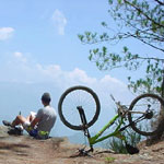
Drawing
The climb was so steep I had to make a stop on a lookout point. The
view was breath-taking it felt unjust to abruptly move on. I took out my sketch pad and started drawing. This is one occasion where the compulsion to capture the scenery took precedence over the punishment of the climb. I couldn't get over myself I started texting some friends on where I was and what I was doing.
Wawi replied likening me to an eagle spreading my wings. Others, whom I considered close and intimate replied, "who's this?"
Ambasing / Balugan
I held back on the downhill fearing my brake cable might snap. I couldn't just feather my brakes. I had to squeeze it for the most part. It felt
suicidal to white-knuckle the deep ruts, sandy sections, loose rocks and the big drop to the bottom. Upon reaching the base, I headed further west into the town of Ambasing and then further out to
Balugan. The road stopped there. It was a hike along rice fields and mountain sides.
I took the opportunity to talk to the local storekeeper. He told me a bit about the culture, tribal ownership of land (they can't sell it to have it available for future generations), trees (they can chop it down to build their house but not to sell the wood), and about the surrounding villages, some accessible by a few days hike further into the mountain.
Mobility of a Bike
Had I hiked to Balugan, it would have taken me half the day and I would have to turn back. With a bike, the remotest village was only minutes away. It afforded me the mobility to ride further out and explore places reserved for those willing to camp it out. It was a different dynamics altogether.
--- TheLoneRider
Day:
1 |
2 |
3 |
4 |
5 |
6 |
7 |
8 |
9 |
10 |
11 |
Baguio |
MTB Race

»» next story: The Cordillera - Day 9: Sagada
»» back to Mountain Biking
»» back to Homepage
|


 Outdoor Adventure Tours
 SandCastles Palawan Beach Resort